


lunedì, 21 ottobre 2013 - Written by: Titi Melis
SEED – Geographic database and Management Plan
CATEGORY: Featured Maps
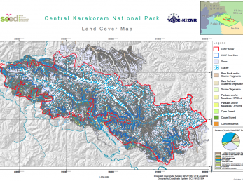
As part of the SEED project a geographic database has been developed to support future planning and management of natural resources. A series of thematic maps has been created to share with the local population management choices concerning the keeping of particular sensitive areas and the use of resources. The data used are derived from satellite images and field surveys. A new methodology based on the integration of NDVI index, DEM and field data has been applied to classify land cover/ land use components using Landsat 5 images acquired on August 2009.